
Dunbeath Strath

Dunbeath Strath is a beautiful Journey following the river into the heart of Caithness with many interesting landmarks to discover along the way.

1. Neil Gunn's Birthplace
The village street of Dunbeath only came into being around 1840 and the Hotel in 1850. The well-known Scottish author Neil M Gunn was born in the house next to the shop and a commemorative plaque is placed above the door. Neil Gunn's book, Highland River, is based on the Dunbeath Water and Strath. The Silver Darlings also describes these areas and those around the harbour, and is set at the time of the herring fishing boom of the nineteenth century. The old bridge built by Thomas Telford in 1812 has now been superseded by the new A9 fly-over as the main route.
2. Old Well
On the seaward side of the old bridge on the north bank of the river is the well that supplied the fresh spring water for the village. This well is also the starting point of Neil Gunn's famous book 'The Highland River'

3. Meal Mill
Upstream of the bridge on the north bank is the Meal Mill built in the period 1850/60 and worked until 1950. It had an internal water wheel indicating this is a comparatively recent construction. There was an earlier mill upstream adjacent to the Inn at Milton. The mill by the bridge was run by the Cunningham family, the last of whom was Adam Cunningham who, despite losing an arm while serving with the Seaforth Highlanders in World War I, returned to run the mill. The mill lade runs around the back of the field beside the mill from a point 150 yards further along the path. A sluice was built across the river to the island at this point to regulate the supply of water to the mill and traces of the stonework are still visible.

4. House of Peace - site of monastery.
Following the north bank of the river upstream one passes a mound with prominent large walls radiating from it and the ruins of the building on the summit. This is known as Chapel Hill or the House of Peace, mentioned in Neil Gunn's The Silver Darlings, traditionally believed to have been the site of a monastery. There used to be a cemetery desides it as the name of the adjacent farm - Ballachly - indicates. Some time after 1860 a cloudburst caused a wall of water to come down the Houstry Burn and washed out a number of coffins from the cemetery. Afterwards the farmer ploughed up the land of the cemetery bringing ill luck on himself and his family. The exact site is not clear today.

5. Dunbeath Broch
Crossing the Houstry Burn by the footbridge, Dunbeath broch is reached by climbing the path to its prominent position between the Burn and Dunbeath Water. A modern wall in the shape of a 'D' has been built around it to protect it from stock. The broch is in a ruinous condition, but in the summer of 1990 Dunbeath Preservation Trust undertook the consolidation work. The guard cell, a further interior cell and the entrance are still evident. Dunbeath broch is the best preserved of several brochs in the Strath. The Annals of Ulster mention of siege if Dunbeath in 680 AD, possibly by Brude, a Pictish king on his way north. One might imagine it was this broch that was besieged.
Continuing on the north side of the river, the path takes you through the lovely hazel, downy birch, rowan and bird cherry woodlands. The Strath is famed for its hazel nuts, which may be picked in the autumn. It is very sheltered and is a haven for many birds including buzzards, which may be seen soaring above and quartering the slopes. If you are lucky you may see the little dark brown and white dipper flitting on the rocks in the river bed and diving under the water in search of small crustacea and caddis fly larvae. It turns the stones over in its attempts to dislodge its prey. Roe deer also live in these woodlands. During the summer months there is a wealth of wildflowers, mosses and ferns to be found.
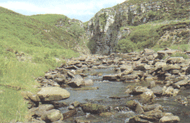
The Dunbeath Water, looking back towards Milton
A meadow beside the river is called the Picnic Green and was, in the past, the scene of many village celebrations. High above the river on the south side is the beautifully situated Balcraggie Lodge, a shooting lodge built in the 1880s (private). Passing up on the path alongside an old plantation of mature beechwoods you come to a grassy mound adjacent to the end of the footbridge, this is the remains of another broch.
6. Prisoners Leap
Still on the north side of the river, we come to a fine gorge known as the Prisoner's Leap. The tradition is that one Ian McMormack Gunn had been imprisoned in Forse Castle by his enemies, the Keiths. He was a native from nearby Braemore. The Keiths said they would release him if he jumped the gorge, which they thought impossible, and by this way they would put him to death. Anyway, Gunn jumped the gorge with a display of tremendous strength due, it is said, to having been an orphan and raised on hind's milk!
The gorge was formed by melting waters from the last ice age which carried large sediment loads of pebbles and gravel and cut the channel for itself through the bedrock, while the land surface was being uplifted as the burden of ice was removed.
Some may like to retrace their steps at this point, but the fleet of foot may like to scramble up the hillside to join the track leading up to the white walls of the cemetery known as Tutnaguail (pronounced Tootnagool), which overlooks a beautiful part of the river.
7. Crofting Settlement
Below the track lie the ruined remains of an old croft, barn and cornkiln. Patterns can still be seen in the meadowland of raised beds made by the run-rig system of agriculture practiced in earlier centuries.
On this slightly higher ground, lapwings, curlews, larks and whitears all come to breed every summer. Their songs and alarm calls fill the air with sound.
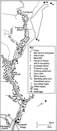
8. Cairn Liath
In this area there are some interesting prehistoric antiquities, like the two chambered burial cairns in the Loedebest area, and the horned long cairn known as Carn Liath. It is of the same type as the Long Cairn at Camster, which has been reconstructed and may be entered. At Carn Liath, it is still possible it see the upright stones (orthostats) which form part of the burial chamber. The tall pile of stones on top of the ruined remains is a modern addition.
9. Stone Quarry
Up the hill to the north of the cemetery is a quarry, perhaps started in the Neolithic period, where it is still possible to see a nearly separated 'standing stone' with stone chocks under it. The technique for quarrying this type of material has been unchanged for 3-4,000 years; gate posts in the twentieth century were still obtained in the same manner.
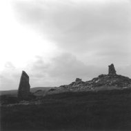
10. Standing Stone and Chambered Cairn
The hill on which the quarry lies is called Cnoc na Maranaich. On its summit is a standing stone. On midsummer's eve this should be aligned with the setting sun and a notch in the hills in the west. Actually, at this stage it no longer aligns, though it has been calculated that in 2000 BC, when the arrangement was in use there was probably an accurate alignment. Also here, adjacent to the stone, is a chambered burial cairn, and close by the cairn is a well.
The hill on which the quarry lies is called Cnoc na Maranaich. On its summit is a standing stone. On midsummer's eve this should be aligned with the setting sun and a notch in the hills in the west. Actually, at this stage it no longer aligns, though it has been calculated that in 2000 BC, when the arrangement was in use there was probably an accurate alignment. Also here, adjacent to the stone, is a chambered burial cairn, and close by the cairn is a well.
From this point you may be rewarded by the sight of a herd of red deer, or you might startle a mountain hare or covey of red grouse from the cover of the heather, with the distinctive cry of 'go-back', 'go-back'.
This concludes the Strath heritage trail and, unless you are equipped for a longer excursion, you should now start your return journey.
Approximate distances
Round trips:
Mill - Dunbeath broch - Mill 1 mile
Mill - Prisoner's Leap - Mill 3 miles
Longer trips:
Prisoner's Leap - Tutnaguil 1 1/4 miles
Tutnaguil - Cnoc na Maranaich 1/8 miles
Cnoc na Maranaich - Mill 4 1/4 miles