Settlement remains
SITE REF: DB09/01
GRID REF: ND 119 303
Height OD: 166m
Within the great bend of the Allt Bad nan Glac, on a slight slope descending to the east, a group of low turf- and peat-covered earth and stone mounds and circles, variously described as 'wags', aisled roundhouses, wheelhouses, hut circles, shieling bothies and cairns. The surface evidence suggests that some sites may have had more than one function through time, with possible later re-use as bothies or shelters in connection with a shieling system.
Described by the OD (1960): On the E-facing slope of Bad nan Glac, are the extremely mutilated remains of galleried structures, presumably 'wags' or aisled-houses, and a probable cairn.
At ND 1195 3041 is a mutilated earth-and-stone mound with several large slabs protruding. It measures 14.7m N-S by 17.7m transversely and is 0.9m high. On comparative terms, this would appear to be the remains of a 'wag'. A small rectangular foundation (6 by 3m) abuts it on the S; 20.0m NW of this is a low pile of stones measuring 4.4m E-W by 3.0m transversely, which seems to be the remains of a cairn.
At ND 1200 3031 is the remains of a round aisled-house (sic) measuring 12.0m N-S by 13.5m transversely. It now appears as an earth-and-stone bank spread to 5.9m on the E side with a maximum height of 1.1m. In the interior on the W side is an orthostat (0.2 by 0.2 by 0.8m high) and there are one or two similar stones lying recumbent. The entrance, 0.9m wide, is in the SE, and immediately outside it is a large flat stone, 2.0m long, 1.3m broad and 0.1m thick.
At ND 1204 3030 is a large mutilated area measuring approximately 24.0m N-S by 22.0m, apparently the remains of a 'wag'. The site is thickly covered with bracken. The interior contains many stones, and several upright slabs are in the S edge of the area forming a small compartment. Traces of a hut circle, some 9.0m in diameter, formed by a course of stones set on edge, abut the site in slightly marshy ground on the SE.
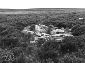
At ND 1188 3025 (pictured) is a mutilated pile of slab-like stones with two orthostats leaning towards each other in the centre, the larger being 0.6m high. This probably represents the remains of another aisled-house, about 6.0m in diameter. Some 50m NNW of this is an area of much loose stone, measuring 13.0 by 9.0m over all, apparently the remains of another 'wag'. Among the stones are a number of upright slabs.