Wags
SITE REF: DB18/20b
GRID REF: ND 1189 3295
SITES & MONUMENTS RECORD REF: ND13SW0010
SCHEDULED ANCIENT MONUMENT
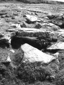
Described by RCAHMS (1911): "On the N bank of the Dunbeath River, about 1 1/2 miles below Achnaclyth on the low haugh by the river, are the remains of two galleried structures. That nearest to the stream has been L-shaped in plan. The longer arm, lying NW-SE, measures some 32 by 18ft, while the other projection measures some 20 by 13ft. The wall, built of large stones carefully laid, is 8ft thick and visible in places to a height of 2ft. The pillars have been placed as usual about 3ft from the side walls. There has been an entrance into the longer arm at its SE end, 2ft 8ins wide, and also probably into the shorter chamber near its junction with the other, in the re-entrant angle, but at this point the outline of the ruin is indefinite. There is an indication of a cross wall between the two chambers. Only one covering slab remains in situ and it appears to form part of the last-mentioned entrance.
"The adjacent structure is much ruined, but appears to have consisted of two circular enclosures NW and SE of each other, of different size, with a third abutting on the N. The circle towards the SE has had an internal diameter of about 22ft. They all contain the usual evidence of galleries."
Described by the OS (1982): "There are two homesteads exposed within two separate and adjacent mounds of turf-covered debris. The SE mound contains an aisled, L-shaped house (A), fully described by the RCAHM (above). The second mound contains at least three contiguous aisled round houses (B-D). House 'B' is 8.0m NW-SE by 7.0 to 7.5m transversely within a collapsed and overgrown wall. In one or two places both inner and outer wall-faces of upright slabs are exposed indicating a wall thickness of 1.5m. The entrance, of simple form, is in the SE arc. No pillar stones in situ are visible among the considerable tumble within the house, but there are a number of displaced lintel slabs. 'C', abutting the NW side of 'B' at a lower level, measures internally some 5.5m NW-SE by 4.5 transversely with some indication of an entrance in the NW arc. The wall is very scant except in the N sector where a crudely coursed inner wall-face, 0.5m high, can be seen; here also i s a leaning pillar with a lintel in situ. House 'D', contiguous with the NE flank of 'B', is very depleted, and the wall generally survives only in occasional slabs of its inner face. It measures 5.0m in internal diameter with possibly the entrance in the N. Within the house is an angular upright, 0.5m high and 0.25m square in section, and several displaced lintel slabs. On the S side of 'B' are the possible remnants of a fourth circular house, surviving as an arc of tumbled internal debris, and no evidence of an aisled construction."