Group of hut circles, possible hut circles and mounds
SITE REF: DB22/15a-h, k, l, m, n
GRID REF:ND 0930 3315 (centre)
SITES & MONUMENTS RECORD REF: ND03SE0017
SCHEDULED ANCIENT MONUMENT
Height OD: 160 (average)
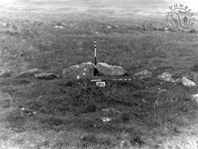
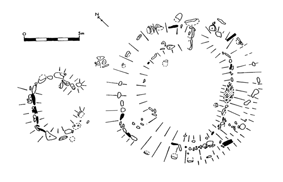
On a less sloping area of hillside to the north-west of the north-western corner of the Bouilag enclosure dyke (DB22-03e), a group of definite and possible hut circles. Listed by OS as "six hut circles," there are at least twelve structures, one of which (DB22-15m) has the appearance of a buried clearance cairn or mound.
Described by the OS (1982) as: "Centred at ND 093 332, in a fairly level area on a N-facing hillslope in open moorland, is a settlement of six hut circles (A-F).
"Hut 'A' is heather-covered and obscured by peat growth; it measures 11.0m E-W by 10.0m transversely within a wall spread from 2.0 to 2.5m and 0.3m high. The entrance, of simple form, is in the E.
"'B', the best preserved (DB22-15l), is 9.0m E-W by 8.5m transversely within a turf-covered wall 0.7m high and spread to 3.5m, broadening to 4.0m at either side of the splayed entrance in the E. An upright slab, 1.0m high, 0.7m long and 0.2m thick, is positioned radially close to the inner side of the hut wall in the SW arc. Stones are exposed in the wall and in the interior of the circle, but no facing slabs can be identified.
"'C' measures 10.5m by 8.0m transversely within an obscured, heather-covered wall spread to some 2.5m and 0.3m high. There is a poorly-defined entrance in the E.
"'D' is heather-covered and measures 10.0m ENE-WSW by 8.5m transversely within a wall spread to 2.5m and 0.4m high. Outside the entrance in the ENE is a scarped platform.
"'E' is very obscured by peat and heather and survives as a platform measuring overall 15.0m NE-SW by 12.0m transversely; the silted entrance is in the NE. Cutting into the wall of the hut circle in the S is a depression, 6.0m long, 3.5m wide and 0.9m deep where it cuts the wall. Several stones are exposed, including a large slab in the side of the depression, but none are in situ and they have possibly been pulled from the hut. This cutting appears to post-date the hut, but its purpose is uncertain.
"'F' is 8.5m in diameter within a wall spread to 2.0m and 0.3m high. Outside the simple entrance in the NE is a low, stony platform."
Situated on a gentle, north-facing slope down to the southern bank of Dunbeath Water, Dail-a-bhoich consists of an enclosure complex, a long-house, an ancillary structure and a large kiln barn. The long-house is approximately 50m long by 4m wide and is divided into 5 rooms. A very typical deserted settlement cluster. The kiln barn has opposing doorways.
Roy's Map (1747-55) shows a cluster of four buildings with the name "Dalrach" in this vicinity.