Deserted settlement cluster
SITE REF: DB16/02
GRID REF: ND 1248 3232
SITES & MONUMENTS RECORD REF: ND13SW0007
SCHEDULED ANCIENT MONUMENT
Height OD: 100m
Orientation: E-W
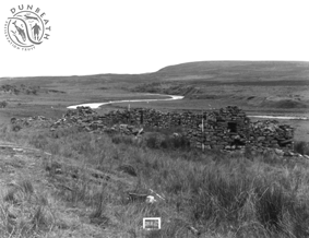
Situated SW of the Dunbeath Water, 1300m W of Loedebest is a post-medieval settlement which comprises the remains of six buildings, associated enclosures and an extensive area of rig cultivation. The six buildings include four which survive as turf-covered foundations and two better preserved structures. A fairly long period of occupation is probably indicated on this site. The enclosure to the E of the settlement is oval in shape. Associated linear dykes and field systems occur on all sides of the settlement.
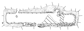
The rectangular, dry-stone built structure pictured is sited on a fluvio-glacial terrace above the Dunbeath Water. It is a long building with one internal partition. Much reduced, mostly turf-covered foundations with some stone visible.