top of page
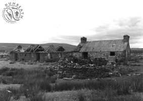
Long house, Loedebest
SITE REF: DB18/17
GRID REF: ND 1376 3217
SITES & MONUMENTS RECORD REF: ND13SW0036
Height OD: 107m
Orientation: NE-SW
Long rectangular building with NE end fully preserved. Corrugated iron roof and surviving chimneys are either end in a structure which appears still be used as an animal/shepherd shelter, although the SE end is ruinous. Buildiing originally had cruck-supported roof; the slots are preserved in the walls and one cruck roof beam has survived. The roof has been replaced and elsewhere a nailed structure supports the remnants of a turf roof. Doorways in SE side.
This has been a settlement site since at the least the first half of the 18th century, appearing as "Lodbas" on Roy's Map (1747-1755).
Please reload

bottom of page
